A little early morning fog

I drove north to the Sleeping Bear Dunes National Lakeshore earlier this week. It is a trip I take regularly. My drive takes about 3 hours. The anticipation builds as the first hints of morning light begin to reveal the conditions. The last three times I have made the trip, I drove through areas of fog, giving me hope that my destination would be shrouded with interesting atmosphere. On my previous two trips, the fog dissipated about 5 miles from the lakeshore. But, Tuesday a low fog hung on for me.

Noticing that the fog lingered in open fields, I decided to start photographing in the Point Oneida Rural Historic District. I started at the Pete and Jennie Burfiend farm. I have taken photos of this old granary at all times of the year. Enamored of its simplicity, I am drawn back time and time again.

Up the road from the Burfiend granary is the Martin and Allay Basch Farm. Fog engulfed the fields on both sides of the farm buildings.

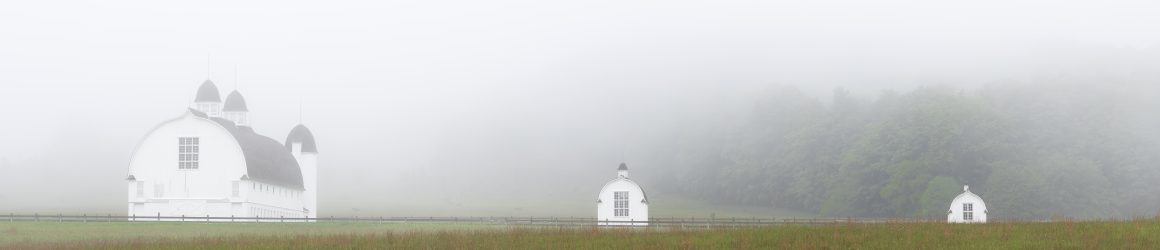
Continuing on Baker Road (formerly known as the “Back Road”), I came to a clearing that overlooks the wetlands along Kelderhouse Road and took this panoramic shot.

Off to the side of the clearing was this tangle of poplars.

The clearing also overlooks the Carsten and Elizabeth Burfiend farm on Point Oneida Road. The Burfiends homesteaded the land, which sits on the bluff above Sleeping Bear Bay, in 1852.

I ended my morning shoot photographing the Tucker Lake wetlands along S. Westman Road. This area has frustrated me in the past, as it was just a little bit beyond the reach of my 70-200 mm lens. I recently upgraded to a 70-300 mm lens, which enabled these shots.

Once in a Blue Moon

On Saturday, we had a full moon for the second time in October. The moon set at 8:10 a.m., so I thought it would be good time to capture a photo of the moon close to the horizon. Things didn’t quite go as I had planned, but it was a wonderful morning for photography.

Prior to my trip to Sleeping Bear Dunes National Lakeshore, I used a couple of apps to find the right spot to shoot the setting moon. I needed something of interest in the foreground. What I hadn’t considered was that it would be dark and cold. I hadn’t given enough thought about how to balance a dark foreground against the brilliant light of a full moon. Still, I got this shot, which I like very much.

I chose to shoot the setting moon at a familiar spot, the Peter and Jenny Burfiend farm at Point Oneida in the Sleeping Bear Dunes National Lakeshore. Sunrise would follow the moonset by about 15 minutes, so as I stood in a field, the sky became brighter, allowing enough light that the granary was no longer silhouetted.

According to a map I have of Point Oneida, this is the old pig house on the Burfiend farm.

As the sun came up, I was surprised to see the beautiful fall colors still on the trees. This is the house on the Burfiend farm.

After the sun came up, I stopped by Bass Lake. I had stopped there three weeks earlier when the colors were just coming on

The colors were stunning.

After stopping at Bass Lake, I drove to nearby Narada Lake. The corner of the lake near the Sleeping Bear Heritage Trail had a thin layer of ice that would disappear later in the day.

The view across Narada Lake was every bit as stunning as that on Bass Lake.

In the shadows of Narada Lake I saw this reflection of the leaves and a single dead tree that was bleached white.

Lily pads were frozen in ice.

This is the barn on the Lawr farm, which adjoins the Burfiend farm.

George and Louisa Lawr established the farm in the 1890s and and continued to farm there until 1945.

My last site for shooting was along Westman Road, in the wetlands north of Tucker Lake. These berries caught my eye.

The bright yellow tree is a tamarack, also known as an Eastern Larch. Tamaracks are conifers that grow in the wet soils around swamps and bogs and near lakes. Unlike other conifers, each fall their needles turn bright yellow and fall to the ground.

These maples leaves had fallen onto the ice in the wetlands near Tucker Lake.

The weather forecast called for snow on the Leelanau Peninsula last evening. I am sure the next time I venture north, the area will present starkly different things to photograph.

Chasing Fall Colors

On Saturday I headed to Sleeping Bear Dunes National Lakeshore hoping to find fall colors. I got an early start, as usual, arriving an hour before sunrise. Before the sun came up I shot several photos, experimenting with intentional camera movement. No two photos are the same. And sometimes the result is surprising.

The forecast was for a cloudless sky, which was basically true. But this band of clouds appeared and stretched across the sky.

As the band of clouds moved south, it caught the light of the sun, which was still below the horizon.

Shalda Creek flows into Good Harbor Bay. The salmon were running, heading upstream to spawn.

In the northern part of the park, the trees had not reached their peak color, but I was able to isolate some patches of color reflected in Bass Lake.

Birch trees at Point Oneida. The trees are no longer alive. They have been drowned by an expanding beaver pond and now serve as food for the beavers.

Looking down at North Bar Lake from stop number 10 on the Pierce Stocking Scenic Drive. This view shows just how green it was close to Lake Michigan.

The fall colors became much more vivid as I got a bit more inland from Lake Michigan. So I stopped at the Brown Bridge Quiet Area near Traverse City for some quick shots before coming home.

The meadow in the Brown Bridge Quiet Area used to be under a pond that was created when they dammed the Boardman River. The dam was removed in the summer of 2012.