I headed north on Saturday, a day after the vernal equinox, to see what was left of the ice on Lake Michigan. Ice break up can be pretty dramatic as the wave action pushes large slabs of ice onto the shore. Here are a few images from my morning on the shore.
Earlier this week, I traveled north to the Leelanau Peninsula to see what winter has brought to northwest Michigan’s shoreline. I began my exploration in Frankfort, Michigan, where the Betsie River flows into Lake Michigan. Snow and sand were piled up on the beach while the lighthouses that mark the opening of the harbor were covered in ice.
On the shoreline was a collection of benches. They faced the town, but one bench stands sentinel, looking towards the lake.
A few miles north of Frankfort, is the Point Betsie Lighthouse. I have photographed here many times. It is especially interesting in the winter when the ice forms of the trees and the breakwaters.
North of Frankfort, after you enter the Sleeping Bear Dunes National Lakeshore, you cross the Platte River. I followed the river down near where it enters Lake Michigan. As it makes a turn to the lake, it cuts through an area of dunes.
Sand Dunes on the Platte River
Another ten miles or so north is Empire, Michigan. As you stand on the beach, Empire Bluff is to the south, while the Sleeping Bear Dunes are in this distance to the north.
Empire BluffSleeping Bear Dunes
I stopped near the Dune Climb to photograph the frozen mill pond and the snowy dune.
Sleeping Bear Dunes
I finished my trip with a visit to Good Harbor Bay, where Shalda Creek flows into Lake Michigan. It always interests me to see the path the Creek cuts to make its way to the lake.
It has been a good old-fashioned winter in Michigan this year. For those of us who like winter, it’s been great, with snowfall running significantly ahead of our average. The downside is that we have seen relatively little sunshine. And, oh, has it been cold.
Over the weekend, we had a rare few days of clear skies and sunshine. I braved the cold and visited Honey Creek and Lake Michigan to make some photos.
Late afternoon on Honey Creek, the shadows were long and deep. The creek is open in just a few spots as snow blankets the many trees that have fallen across the creek in the last couple of years.
On Sunday, I headed to Lake Michigan before dawn. The thermometer on my car read -4 degrees as I set out and rose to a balmy zero degrees by the time I arrived at the pier at Grand Haven State Park. There was no wind, but, in the bitter cold, my fingers hurt so much that it was difficult to operate the camera. Working quickly, I did my best and then headed off to a coffee shop to warm up.
A birch tree at Grand Haven State Park.
If you know of someone who is missing a slipper, they can find this one on the beach at Grand Haven.
After warming up, I drove north of Muskegon to get a view of Lake Michigan. The lakeshore is a frozen desert reaching far out into the lake.
The weather forecast called for our first frost of the season last night. That meant we would likely see fog rising from inland lakes. So I made the easy trip the Yankee Springs Recreation Area and Hall Lake. I have visited Hall Lake many times in the fall. This year the colors were not as vibrant as on past visits, but the fog made for some fun photography.
I arrived about an hour before sunrise and watched the scene reveal itself as the sky lightened and the sun, still below the horizon, painted the clouds.
I focused my attention on the smaller of two islands in the lake taking several photos as the sun began to illuminate it.
I traveled north to Sleeping Bear once again, this time with reflections on my mind.
The sky reflected in the Platte River as it flows towards Lake Michigan.Two anglers at the mouth of the Platte River where it flows into Lake Michigan.Mist on Bass Lake.Cedars and mist on Bass Lake.Reflections on the Crystal River.
Suzanne Fritz-Hanson, who co-hosts the Everyday Photography Every Daypodcast with photographer Michael Rubin, coined the phrase “get the cliché out of the way” to suggest how photographers should deal with the urge to take the obvious photo that everybody snaps. Who can resist taking a photo of Tunnel View in Yosemite Valley or a sunset over Lake Michigan? And why shouldn’t you take your own photo of the iconic scene, even if it is a cliché? Once the cliché is in the bag, you can move on to shooting popular subjects from unusual points of view and creating original images.
I recently returned from spending a week with my family at my frequent haunt, Sleeping Bear Dunes National Lakeshore. The focus of the week was spending time with my son and his family, but I did get out in the early morning and on a couple of evenings to take some photographs. In the limited time I had, I fell back on the clichés, photographing things I have seen countless times before. My excuse is that I was working with a new camera, learning how to use all the new features. And besides, it was fun. So here’s a mishmash of photos from the trip.
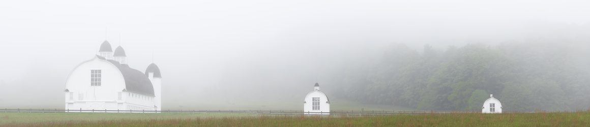
What could be more cliché at Sleeping Bear than a photo of the iconic barns on the D.H. Day farm? I was there on two foggy mornings and couldn’t resist.
This tree that stands in Narada Lake may not be an iconic image, but it is one I frequently photograph, hoping to find the right light and right angle to make a compelling image. I rarely succeed. But this sunrise with bands of clouds made the scene worth taking.
On another foggy morning, I headed to North Bar Lake. The fog had mostly lifted but the reflection of the trees and the dune in the water and the curvature of the cloudbank drew my attention.
The fog lingered on the south end of North Bar Lake. There, I noticed a pair of Sandhill Cranes walking along the beach and approached them cautiously to get this photograph.
If you search for “Teichner” on this website, you’ll see that I have photographed the cedar trees at the Teichner Preserve several times in the last six years. Perhaps the site is becoming cliché for me, but I am drawn to the location and keep looking for new perspectives on the scene. (If you are looking at this on a computer rather than a phone, click a photo to seen an enlarged image.)
Another site I return to often is the Basch farmstead in the Port Oneida Rural Historic District. The simplicity of the house and the granary continue to draw my eye. The light on this evening reminded me of the light in some of Edward Hopper’s paintings.
One evening when the conditions seemed right, I headed to the beach at Port Oneida to photograph that mother of all clichés, a sunset over Lake Michigan. When I pulled into the parking area, I was captivated by the dappled light on the trees.
On the shore, I waited and waited for the ball of the sun to appear. It never did. Others who were on the beach with me impatiently left, but I waited around to see how the setting sun would light up the clouds. Taking a long exposure, I captured a beautiful, soft glow as the sun slipped below the horizon – a photo I would consider more than a cliché .
I had an opportunity to spend the night in Glen Arbor to do some night photography at the Sleeping Bear Dunes National Lakeshore. I had hoped to photograph the Milky Way, which is making its annual reappearance after wintering below the horizon. I did my homework, using the Photopills app to find a good viewing point, and checking six different models for the weather forecast. According to my research, if all went well, I would have clear skies between midnight and 1 a.m., when the Milky Way would be visible across the horizon at Sunset Shores Beach.
I visited Sunset Shores Beach on Thursday afternoon to scope out a place to set up later in the evening. Unlike Good Harbor Beach and Esch Road Beach, Sunset Shores Beach has some large stones, including an erratic boulder, which I hoped would make a nice point of interest for the foreground.
I came back to the beach to catch the sunset to make a few photos. If everything went as planned, Sunset Shores seemed like the perfect spot for photographing the Milky Way.
Well, the weather cooperated. The clouds didn’t roll in until after 1 a.m. But, apparently there was a little operator error in using my Photopills app to determine when the Milky Way would rise above the horizon. I didn’t see the Milky Way, but I had a wonderfully clear evening to try work on my night photography (a work in progress).
The erratic boulder did a nice job anchoring the foreground. And the ten-second exposure smoothed the waters of Lake Michigan. No Milky Way, but a nice shot of the celestial heavens. I’ll have to figure out what I did wrong for when I have another opportunity to enjoy the night sky at Sleeping Bear.
So far this year, Leelanau County (Michigan’s little finger) has had 124 inches of snow. I took advantage of this yesterday and visited Sleeping Bear Dunes National Lakeshore, making a random group of images.
As always, the sun came up yesterday, but it was hidden behind a blanket of dense clouds and blowing snow. Shortly after sunrise, I began taking photographs on Aral Road, a two-track that passes over Otter Creek. Setting up my tripod spooked the ducks that were floating in this old vestige of the mill pond that was here when the creek was dammed and a saw mill was located just a bit downstream.
Near the creek, a sumac tree was outlined in white.
I stopped by the Tweedle Farm. The red of its outbuildings and the rust on the silos stood out against the gray sky and white snow.
The Mill in Glen Arbor is an old grist mill on the Crystal River. It has been wonderfully restored and given new life with a couple of restaurants and great space to relax by the river.
I can’t stop taking photos of the granary on the Peter and Jenny Burfiend Farm in the Port Oneida Rural Historic District. The stark geometry and bright white of the granary make it stand out against the landscape, even when the landscape is covered with snow.
This is a photograph I took years ago of the Burfiend’s house that they built after establishing the farm in 1882.
I took this photo of the garage on the farm yesterday.
Across the field and beyond a swamp on the shore of Lake Michigan is the farm of Peter Burfiend’s father, Carsten, and mother, Elizabeth. There are several outbuildings on the farm, but only the foundations of the barn and silo remain.
On the way home, I stopped in the southern portion of the park where the Platte River flows into Lake Michigan. There I found a spot where the snow had blended with the sand of a dune between the river and the lake.
Yesterday, I posted about my visit to Shalda Creek last week. That got me looking back at images I made in December on Esch Road Beach, where Otter Creek flows into Lake Michigan. In my past visits, Otter Creek flowed almost directly into the lake. Conditions have changed, however. Lake Michigan has dropped several inches in the last year, dipping about 5 inches below historic levels and expanding the beach. So the creek has had to cut a new path to the lake. I was surprised to see that the creek has taken a left hand turn and run parallel to the shore for about fifty yards before flowing into the lake.
I came to the beach hoping to make some abstract images of snow and sand mixing together similar to this photograph, which I took last January.
I liked the way the sand and the snow blended together. But, alas, this year there was no snow on the beach. I continued to scout around and found some interesting images along the shore of the creek.
As I write this on the tenth day of November, fall has entered its final stages. The trees are done showing off, no longer flashing their brightly colored leaves. Their branches are now mostly exposed, revealing the superstructure of the forest. I traveled to northern Michigan this past week to spend a couple of days exploring the woods, looking for smaller, more intimate scenes that seem to become more evident when the trees stop showing off.
Most of the ferns in the forest were brown and withered. But, at Misty Acres in the Borwell Preserve in Benzie County, I found this bulblet fern that had found sanctuary in the bark of a tree.
At the Houdek Dunes Natural Area in Leelanau County, my eye was attracted to the yellow plant and the green pine tree seemingly enjoying their time in the sun.
I came across these tiny fungi that had latched onto a birch tree. I believe they are called orange mycena.
The Teichner Preserve in Leelanau County is a small preserve on the shores of Lime Lake. There is a short trail that leads from the road to the lake and a spot I call the “Gathering Place.” There, the cedar trees are in a struggle to avoid succumbing to waves that erode the shoreline. Their roots intermingle as if they are holding onto each other for dear life.
I stopped at the Howard & Mary Dunn Edwards Nature Sanctuary in Grand Traverse County specifically to get photos of the larch trees. Larch trees are the only coniferous trees that lose their needles each year. Before doing so, they turn a vibrant yellow.
Along the pathway, I paused to take photos of the brightly colored leaves and needles that were still hanging on.
Here’s a couple of other things that caught my eye along the trail.
At Sunset Shore beach in the Sleeping Bear Dunes National Lakeshore, I took time to enjoy the setting sun as a stiff wind blew on shore. In the woods above the beach, I came upon this cedar that grew up around some boulders. All in all, a wonderful couple of days in nature.