Here is my submission to the Glen Arbor Arts Center‘s Members Create exhibit this summer. Titled Quiet Moments, it is a triptych of images taken during in the winter of 2018. Winter is my favorite season in which to do photography. Dressed in layers, I willingly endure the cold so that I can enjoy the solitude of the beach. Except for the sound of the waves, the world is silent, muffled by the layers of snow, and I embrace the peaceful feeling that wells up in me.
The images are separately framed, but have always been exhibited together. The Members Create exhibit runs from June 6 to August 7, 2025, at the Arts Center at 6031 South Lake Street in Glen Arbor. The gallery is open Monday through Friday from 9 a.m. to 3 p.m. and Saturday from 12 p.m. to 4 p.m.
As I write this, 2024 is quickly coming to a close. Time once again to look back and select some photos from this year that I especially like.
This year was a little different from previous years because my main photography focus for the year was researching and preparing two lectures that I delivered in November at the Osher Lifelong Learning Institute (“OLLI”) at Aquinas College. The lectures were titled, “Editing Reality: The History of Manipulated Photography.” The first lecture dealt with the period before the digital age, while the second began with the digital age and got into the consideration of the impact of artificial intelligence on photography. I had a blast doing the research, reading a wide range of sources and, though the lectures are done, my reading continues to focus on the history of photography.
Incidentally, I was honored that OLLI sought my permission to use my photographs on their Fall and Winter Course Catalogs.
I am principally a landscape photographer who shoots in what some have termed, “the eyewitness tradition.” I edit my photos to create a realistic image that truthfully presents how I saw what was before me when I clicked the shutter. I do not use generative artificial intelligence or insert items into my images that were not before me. That said, this year I experimented making multiple exposure and montage images. There were two that I particularly liked.
I created this first image from three exposures taken of the side of a dumpster at the East Grand Rapids Public Works Facility. I blended them together in Photoshop. I rather liked the result.
This tree is one of my favorites. Standing alone in a farmer’s field, it reveals its majesty. On the day I took this photo, the sky was cloudless. While the sun was shining and the sky was a beautiful blue, to my eye, the sky offered nothing of interest. Photoshop now allows one to replace the sky with a menu of clouds. Doing so seems disingenuous and certainly would violate the eyewitness tradition I adhere to. Rather than create an artificial photo and present it as real, I chose to try something a little different – a composite of two photographs, one the photo of the tree and the field, the other an image of the bark of a tree for the sky.
Earlier this year, the Glen Arbor Arts Center put out a call for entries to a juried show titled “The Sky is Always There.” The prospectus called for entries that “move beyond direct representation, beyond portraits of puffy clouds.” I was eager to try to get something accepted for the show, but my photography is very representational. I gave it much thought but was coming up empty. Then, after creating cyanotypes of leaves and twigs with my grandchildren I got the idea of submitting photographs of the night sky processed as cyanotypes for this exhibition.
I selected three digital images – a moonrise, the Milky Way, and the northern lights – to create a triptych. From the digital files, I created monochrome negatives of each image. I used a mixture of ammonium iron citrate and potassium ferricyanide to sensitize hot-pressed, 100% cotton watercolor paper to UV light. Then I made contact prints from each negative by exposing the negative and paper to a UV light source. To deepen the blues, I bathed the final prints in hydrogen peroxide.
I am pleased to say that the juror selected my entry for the exhibit, which will run from January 10 to March 20, 2025, at the Glen Arbor Arts Center in Glen Arbor, Michigan.
Here’s a selection of more straightforward images that are among my favorites for 2024:
“Sunrise on Sleeping Bear Bay,” Sleeping Bear Dunes National Lakeshore
“Hall Lake Morning,” Yankee Springs Recreation Area
“Lake Superior Lakeshore from Above,” Pictured Rocks National Lakeshore
“Lake Superior Stones,” George Hite Dunes, Eagle Harbor, Michigan
“Milky Way,” Port Oneida Rural Historic District, Sleeping Bear Dunes National Lakeshore
“Northern Lights over White Lake,” Wabaningo, Michigan
“Hanging On,” Teichner Preserve: The Leelanau Conservancy
“Fall Foliage,” Howard and Mary Dunn Edwards Nature Sanctuary, the Grand Traverse Regional Land Conservancy
“Turkey Tail and Maple Leaf,” Houdek Dunes Natural Area: The Leelanau Conservancy
In the coming year, I will continue to research the history of photography. Of particular interest to me are cabinet cards created in the second half of the 19th century. I will also continue to deepen my understanding of generative artificial intelligence and its impact of the art of photography. And, of course, I will continue to get out with my camera in an effort to capture nature’s beauty.
Happy New Year
Here are links to my my year-end review of images in 2019, 2020, 2021, 2022 and 2024.
I returned to Hall Lake this morning in the Yankee Springs Recreation Area. I had been there last week when I took this photo of the roots of a white pine tree.
Returning this morning I was treated to fog on the lake, which added some added interest to the photos.
As a result of a severe solar storm, a vibrant show of the northern lights appeared last evening in latitudes more distant than usual from the poles. The internet today is humming with photos from around the northern hemisphere. My wife and I drove about an hour from our home to Wabaningo, Michigan, to watch the show, and what a show it was. Here are some photos.
My photo “Exposed” is currently on display at the Glen Arbor Arts Center as part of its “Members Create” exhibit. The exhibit runs until August 8, 2024. The exhibit can be viewed online by following this link.
In the 1920s, photographer Man Ray began processing photographs using a process called solarization “to create a photograph that would not look like a photograph.” Ray created his solarized photos by exposing a photographic print in the wet darkroom to a brief flash of light. Solarization created an unpredictable reversal of tones giving a photograph an otherworldly quality. I attempted to recreate the effect in the digital darkroom by adjusting the tone curve on this photo of a cedar tree whose tap root has been exposed by erosion along the shore of Sleeping Bear Bay.
Winter finally came to Michigan in a big way. This past weekend in Grand Rapids, we received about 17 inches of snow. Prior to that, the snowfall had been minimal. That was the case in the northern lower peninsula, as well. Frankfort, Michigan, in Benzie County, had just 2.5 inches of new snow in December, 21 fewer inches than normal. So far in January, Frankfort has received 21.8 inches.
With this blast on winter, I had to drive north to check it out and do some photography. On Wednesday, I visited the Point Betsie Lighthouse, just north of Frankfort, perhaps one of the most photographed lighthouses in Michigan. I arrived about 8:45 a.m. and had the place to myself. No wonder. The wind was gusting to 30 mph and the windchill was about ten below zero. I was able to stand outside for about 10 minutes before my fingers were so cold, it was hard to operate the camera. I retreated to my car, put on some heavier gloves, put foot warmers in my boots and headed up to the Sleeping Bear Dunes National Lakeshore, where I photographed in woodlands, where I was protected by the wind. My 10 minutes in the deep freeze were productive, however. Here are the keepers among the photos I took.
At the end of each year I look back at the images I have taken and select several to highlight in a year-end post. This year I have selected 15 photos to share and discuss. Whether these images are my “best” or not, I am not sure. But, they are all images that gave me a sense of achievement in expressing my vision.
Winter Scenes
I will start with four images I took in the winter. Winter is my favorite time to do photography. I love being outside in the winter. I find the cold and the snow to be invigorating. Snow can be a landscape photographer’s friend helping to reduce the chaos that so often typifies a scene in nature, especially in a woodland. I have photographed this sumac several times over the years, but found it difficult to get it to stand out from the trees behind it. I made this photograph in a snow storm, which helped to reduce the chaos in the scene, creating separation between the twists and turns of the sumac and the forest in the background.
I first came across this lone tree in a farmer’s field in the fall of 2021. I described it then as one of my “U-Turn” photos – a scene that caught my eye as I was driving by and caused me to do a u-turn. It happened again this past winter. I drove by this tree while it was snowing and again did a 180 and pulled off by the side of the road. A lone tree is a frequent subject for landscape photographers. It can evoke a range of emotions, such as isolation, tenacity, or independence. Having captured a photo in the fall and winter, I will have to return to this spot in the spring and summer to document it in all four seasons.
Walking along Shalda Creek where it enters Good Harbor Bay in the Sleeping Bear Dunes National Lakeshore, I saw these stones frozen in ice. As I photographed them, a haiku came to mind:
Stones encased in ice
Imprisoned by winter’s cold
The beach in February
A good photograph has something in common with a haiku. A haiku expresses its meaning in three spare lines – no wasted words or syllables. In a photograph, everything has to contribute – no extraneous things to distract from the subject.
On my frequent drives to the Leelanau Peninsula, I pass the Weldon Township Cemetery in a clearing cut from the forest. I have stopped several times to try and capture the emotion of the scene without success. But, the winter’s snow helped to emphasize the simplicity of this hallowed place and to convey a sense of repose and honor.
My Swan Vigil
In March, I went for a walk along Reeds Lake in East Grand Rapids, Michigan, and came across a swan sitting on a nest. I continued to visit the nest for two and a half months, hoping to be able to document the hatching of the swan’s nine eggs. The eggs never hatched, but I was able to put together a blog piece on my vigil. Here is the link. The male swan (the cob) was very protective of the nest. In this first photograph, the swan is taking off to confront another pair of swans a couple hundred yards away – apparently too close for the cob.
In the area of the swans’ nest there were many nesting geese. The cob policed the area to let the geese know their place in the order of things. Photographing birds was a challenge for me. I take photos of landscapes with my camera on a tripod, often with a long exposure time. I have the luxury of time to frame a shot and try different apertures and focal lengths. But birds don’t wait for you. You have to react and hope that you snap the photo at the decisive moment. I learned to observe and anticipate.
Iceland
In September, my wife and I visited Iceland. We concentrated our journey in Reykjavík, on the Snæfellsnes Peninsula, and along the southern coast. Iceland is an amazingly beautiful country. Berserkjahraun, seen below, is a vast lava field on the Snæfellsnes Peninsula that formed 4,000 years ago. The lava field is covered with moss and lichen and offers a stunning view with mountains in the background.
I had never photographed the northern lights before. I got the opportunity when we rented a cottage on the southern coast, near Kirkjubæjarklaustur. We watched for nearly four hours as the aurora filled the night sky. The naked eye saw only the greenish colors, which danced in the sky. But, a longer exposure – nine seconds or so – captured the magenta.
On the southeast coast of Iceland is Jökulsárlón, a glacial lagoon dotted with icebergs that break off a glacier and make their way to the sea. My eye was attracted to the layers of tones in this scene.
Iceland has over 10,000 waterfalls. Probably the four most visited falls are Öxarárfoss at Þingvellir, Gullfoss on the Golden Circle, and Seljalandsfoss and Skógafoss along the south coast of the country. All have large parking areas to accommodate the tourists who flock to the sites. We ventured off the main highway to a less visited waterfall, Gluggafoss, also known as Merkjárfoss, where we had the site almost to ourselves (other than the one woman in a bright red coat who kept walking into my photo while talking on her cellphone). Gluggafoss falls in two stages and has a total height of 171 feet. The lower falls are captured in the photo below.
Black and White
I continue to try to develop my eye for processing photos in black and white. Gluggafoss rendered well as a black and white photo, with a broad range of tones.
Back home in Michigan, I look for scenes that I think will be effective in black and white. Processing in black and white reduces a scene to its essence. It relies on structure and form, light and shadow to carry the photograph’s meaning. The great Magnum photographer Elliott Erwitt, who died in November, said of black and white photography, “Color is descriptive. Black and white is interpretive.”
I am attracted to the roots of trees, so I was excited when I came upon these cedar trees along the shore of Lake Michigan. Waves had eroded the shore exposing the lateral roots and tap root that have supported the trees for tens of years. Another period of high water and waves will likely mean the end for these trees.
I was recently studying the work of Wynn Bullock and came across his solarizations. Solarization is a technique in analog photography perfected by Man Ray. When developing film in the dark room, Man Ray would briefly flick on the lights which would invert some of the tones in the finished photograph. In my digital darkroom, I attempted to emulate this process by adjusting the tone curve in Lightroom, lifting the deep blacks while maintaining the midtones and highlights. I found it difficult to emulate solarization effectively, but I did like the effect my method had on this image of the cedar roots.
A Gift
Sometimes an image is simply a gift. I parked in a parking lot in Glen Haven, Michigan, hoping to take some long exposure photographs of waves coming ashore in Sleeping Bear Bay. As my luck would have it, the bay was virtually still that day. When I walked back to my car, the sun had just crested a row of trees to the east lighting up these empty milkweed pods. Simple and beautiful. The experience brought to mind another quote by Elliott Erwitt: “To me, photography is an art of observation. It’s about finding something interesting in an ordinary place. . . I’ve found it has little to do with things you see and everything to do with the way you see them.”
Thank You
If you have gotten to this point, thank you. Over the course of the past year, I have become less and less interested in posting photos to social media sites like Instagram, where people breeze by the photos, swiping left or right, giving little time to each image. So I appreciate your giving me the gift of your time to look at and consider the photos in this post.
Here are links to my my year-end review of images in 2019, 2020, 2021, and 2022.
Cross country skiers and snowmobilers must be very disappointed this winter. The snow brought by the Christmas week blizzard disappeared almost as fast as it arrived. But this past Friday, just a couple hours north of our home, my wife and I found a winter wonderland. The snow was not deep, but the trees were flocked with snow. It was so beautiful, I returned on Saturday to see if I could capture the scene in some photos.
I left Grand Rapids early and arrived at Rosie’s Country Cafe in Thompsonville for breakfast and to await the sunrise. When the sun came up, I was disappointed. While some snow remained on the trees, it was nothing like the day before. Nonetheless, I continued on my way to the Betsie River Pathway. The Pathway has about ten miles of trails. I chose to hike the 2.7 mile West Loop, which passes through a meadow and forest reaching the Betsie River to the west. While it was nothing like I had hoped for, I found a few areas where the snow still clung to the grasses.
Still, there was much to see and enjoy on the hike. The footpath through the forest was carpeted with leaves.
Along the footpath, I took time to explore an ice-covered pond filled with colorful leaves.
After my hike, I headed north on County Road 677 to explore a campground I had found on the map. About two miles up the road, I came upon the snow globe we had seen the day before!
Along County Road 677 is the Weldon Township Cemetery. The cemetery always catches my attention, with its simple white crosses decorated with artificial flowers and American flags. I have stopped before, without success, to try to capture the feeling of reverence I get whenever I pass it. This time, I think I got it.
It’s that time of year again, time to look back at over the past 12 months. The year 2022 offered me some wonderful opportunities to share my work. In addition, we had the opportunity to travel abroad, in the course of which I was reminded of a valuable lesson. Here are some thoughts on the past year and several of my favorite photos taken in the last 12 months.
SHOWING MY WORK
The Glen Arbor Art Center exhibited six of my photos in its lobby gallery at the start of the year. The show, titled Woodland Studies, was my first opportunity of its kind, for which I am extremely grateful to the Art Center and to the Art Center’s Gallery Manager, Sarah Bearup-Neal. Sarah guided me through the process of curating the exhibit and getting it ready to show. Sarah and I recorded a video conversation about the photos in the exhibit, which you can find here. The online version of the exhibit is no longer on the Art Center’s website, but you can view it here.
The Art Center provided me with two other opportunities to display my photos. The following photo was displayed as part of the annual “Members Create” exhibit in April and May. The exhibit is a non-juried show open to members of the Art Center.
Silver Lake Sand Dune, Mears, Michigan
The Art Center also invited me to submit photos to the “Small Works Holiday Exhibition,” where artists display small, original art work for sale for $150 or less. I displayed eight photographs, three of which were taken in 2022.
“Golden Pond”“Lily Pads on Ice”“Lone Tree in Fall”“Morning Light”“Morning Reflection”“Only That Day Dawns to which We Are Awake”“Point Betsie Light”“Winter Wonderland Montage”
In addition to displaying work at the Glen Arbor Art Center, I entered a photo in the Ray and Nancy Loeschner Annual Art Competition at the Frederik Meijer Gardens & Sculpture Park. I had not heard of the competition before September of this year, but the timing was fortuitous. Some dear friends of mine married at the end of August. Their registry included an 11×14 frame, which we purchased and gave to them along with a note offering to fill the frame with one of my photos. They chose a photo I had taken of Aria, a wonderful sculpture by Alexander Liberman, which was acquired by the Gardens in 1999. The more I worked with the photo to make a beautiful print, the more I came to love it. I was excited to have the opportunity to enter it in the competition and was gratified to learn recently that is has been selected as a finalist. The final judging will occur in January 2023.
Alexander Liberman’s “Aria”
TRAVEL
My wife and I traveled to Jerusalem and Paris in early June. Of course, I took my camera and I took plenty of snapshots. The snapshots will help us remember the experience, but the photography was not the focus of the trip. I do, however, want to share one photo with you. We toured Sainte-Chapelle on the Île de la Cité in Paris. Sainte-Chapelle was the royal chapel in the palace of the King of France. The chapel was consecrated in the year 1248. The upper chapel has 15 stained glass windows, each 15 meters tall, that include 1,113 scenes from the Old and New Testament. In a crowded chapel filled with tourists there was neither time nor room to take a studied photo, but I was pleased to get this photo, which will serve as a reminder of the most beautiful room I think I have ever seen.
Sainte-Chapelle, Paris, France
MY FAVORITE PHOTOS OF 2022
At the end of the year, I like to look through my photos and select a group of images that are my favorite photos from the past 12 months. Here’s what I came up with for 2022.
The first photo is a close up of Honey Creek in winter time. We don’t have waterfalls or big significant rapids in southwest lower Michigan. But, by focusing close on an ice formation in the creek, a small scene becomes filled with action and drama.
I enjoy being in the forest in winter. I find the stillness, the quiet, peacefulness, and even the challenge of staying warm to be reinvigorating.
I took this next photo in the Silver Lake Sand Dunes in Mears, Michigan. The shifting sands reveal the stumps of trees, such as this one, that were swallowed up by the dunes years ago. The early morning light shining on this stump accentuated the grain in the wood and the embedded grains of sand.
Coming upon the following scene was a pleasant surprise. I was on a trail that passed through a pine forest. The pine trees were so thick and the canopy so dense that little else could grow in the area. I didn’t expect to see anything of interest to photograph along the trail. But a brief break in the clouds created patches of sunlight on the forest floor that brought depth and dimensionality to what otherwise was a monotony of tree trunks.
Michigan is not at its photogenic best in early spring, when the snow has melted and brown is the dominant color. So I bought a dozen tulips and used them as my subject everyday for a couple of weeks. When they were fresh, the tulips exuded their typical elegance. But I found that it there was beauty to be found even as the tulips wilted.
I am attracted to gaps in the forest canopy created by the death of a tree. The gaps permit the sunlight to break through to the forest floor – a patch of hope in the darkness.
We visited Acadia National Park in mid-September. Peak fall color was still a month away, but as we hiked along the Jesup Path, we came upon this scene. It is a bit chaotic, but I thought the alignment of the birch trunks and the splashes of color brought an order to the chaos and made for an appealing photo.
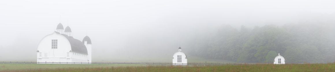
I have shot this scene on Bass Lake in the Sleeping Bear Dunes National Lakeshore many times. (I included a photo of this point of land in my Woodland Studies exhibit.) But on this morning, I was fortunate to be able to shoot the scene in a dense fog, creating a softer, more soothing image.
A key to success in my photography is being aware. These last two photos are of things I might of missed had I not slowed down to take in my surroundings. I found this maple leaf beautifully highlighted by ice crystals when I took a walk on the morning of our first hard frost.
This was another happy find as I explored the shoreline of a local lake on a recent foggy morning.
Here are links to my favorite images of 2019, 2020, and 2021.
AN IMPORTANT LESSON
I learned an important lesson while in Paris. Everywhere we went in Paris, my camera went with me. I made a lot of snapshots. When we entered the Musée de l’Orangerie, I saw a sign showing a camera with a red circle and slash through it – no photography. So I checked my camera and began viewing the museum’s wonderful collection of Impressionist and Post-Impressionist Art. In the galleries, though, I noticed so many people taking photos with cameras and cell phones. The guards did not seem concerned, so I went back to look at the sign again and read the small print: “No flash photography.” I could have retrieved my camera, but chose not to. Without a camera, I explored the galleries with my wife, comparing thoughts about the paintings. I was able to see the art not only through my eyes but also through hers, which enriched my experience immensely.
In the museum that day, I learned in important lesson: sometimes the camera can get in the way of the experience. It’s a lesson I need to remember whenever I go off on a photo shot. I think if I focus on the experience first, my photographs will improve. But even if they don’t, I will find more meaning in those experiences and be a better person for it.