Earlier this week, I traveled north to the Leelanau Peninsula to see what winter has brought to northwest Michigan’s shoreline. I began my exploration in Frankfort, Michigan, where the Betsie River flows into Lake Michigan. Snow and sand were piled up on the beach while the lighthouses that mark the opening of the harbor were covered in ice.
On the shoreline was a collection of benches. They faced the town, but one bench stands sentinel, looking towards the lake.
A few miles north of Frankfort, is the Point Betsie Lighthouse. I have photographed here many times. It is especially interesting in the winter when the ice forms of the trees and the breakwaters.
North of Frankfort, after you enter the Sleeping Bear Dunes National Lakeshore, you cross the Platte River. I followed the river down near where it enters Lake Michigan. As it makes a turn to the lake, it cuts through an area of dunes.
Sand Dunes on the Platte River
Another ten miles or so north is Empire, Michigan. As you stand on the beach, Empire Bluff is to the south, while the Sleeping Bear Dunes are in this distance to the north.
Empire BluffSleeping Bear Dunes
I stopped near the Dune Climb to photograph the frozen mill pond and the snowy dune.
Sleeping Bear Dunes
I finished my trip with a visit to Good Harbor Bay, where Shalda Creek flows into Lake Michigan. It always interests me to see the path the Creek cuts to make its way to the lake.
It has been a good old-fashioned winter in Michigan this year. For those of us who like winter, it’s been great, with snowfall running significantly ahead of our average. The downside is that we have seen relatively little sunshine. And, oh, has it been cold.
Over the weekend, we had a rare few days of clear skies and sunshine. I braved the cold and visited Honey Creek and Lake Michigan to make some photos.
Late afternoon on Honey Creek, the shadows were long and deep. The creek is open in just a few spots as snow blankets the many trees that have fallen across the creek in the last couple of years.
On Sunday, I headed to Lake Michigan before dawn. The thermometer on my car read -4 degrees as I set out and rose to a balmy zero degrees by the time I arrived at the pier at Grand Haven State Park. There was no wind, but, in the bitter cold, my fingers hurt so much that it was difficult to operate the camera. Working quickly, I did my best and then headed off to a coffee shop to warm up.
A birch tree at Grand Haven State Park.
If you know of someone who is missing a slipper, they can find this one on the beach at Grand Haven.
After warming up, I drove north of Muskegon to get a view of Lake Michigan. The lakeshore is a frozen desert reaching far out into the lake.
Suzanne Fritz-Hanson, who co-hosts the Everyday Photography Every Daypodcast with photographer Michael Rubin, coined the phrase “get the cliché out of the way” to suggest how photographers should deal with the urge to take the obvious photo that everybody snaps. Who can resist taking a photo of Tunnel View in Yosemite Valley or a sunset over Lake Michigan? And why shouldn’t you take your own photo of the iconic scene, even if it is a cliché? Once the cliché is in the bag, you can move on to shooting popular subjects from unusual points of view and creating original images.
I recently returned from spending a week with my family at my frequent haunt, Sleeping Bear Dunes National Lakeshore. The focus of the week was spending time with my son and his family, but I did get out in the early morning and on a couple of evenings to take some photographs. In the limited time I had, I fell back on the clichés, photographing things I have seen countless times before. My excuse is that I was working with a new camera, learning how to use all the new features. And besides, it was fun. So here’s a mishmash of photos from the trip.
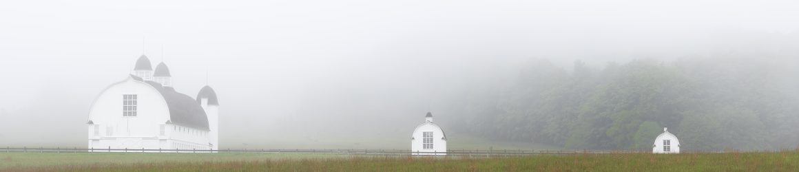
What could be more cliché at Sleeping Bear than a photo of the iconic barns on the D.H. Day farm? I was there on two foggy mornings and couldn’t resist.
This tree that stands in Narada Lake may not be an iconic image, but it is one I frequently photograph, hoping to find the right light and right angle to make a compelling image. I rarely succeed. But this sunrise with bands of clouds made the scene worth taking.
On another foggy morning, I headed to North Bar Lake. The fog had mostly lifted but the reflection of the trees and the dune in the water and the curvature of the cloudbank drew my attention.
The fog lingered on the south end of North Bar Lake. There, I noticed a pair of Sandhill Cranes walking along the beach and approached them cautiously to get this photograph.
If you search for “Teichner” on this website, you’ll see that I have photographed the cedar trees at the Teichner Preserve several times in the last six years. Perhaps the site is becoming cliché for me, but I am drawn to the location and keep looking for new perspectives on the scene. (If you are looking at this on a computer rather than a phone, click a photo to seen an enlarged image.)
Another site I return to often is the Basch farmstead in the Port Oneida Rural Historic District. The simplicity of the house and the granary continue to draw my eye. The light on this evening reminded me of the light in some of Edward Hopper’s paintings.
One evening when the conditions seemed right, I headed to the beach at Port Oneida to photograph that mother of all clichés, a sunset over Lake Michigan. When I pulled into the parking area, I was captivated by the dappled light on the trees.
On the shore, I waited and waited for the ball of the sun to appear. It never did. Others who were on the beach with me impatiently left, but I waited around to see how the setting sun would light up the clouds. Taking a long exposure, I captured a beautiful, soft glow as the sun slipped below the horizon – a photo I would consider more than a cliché .
I had an opportunity to spend the night in Glen Arbor to do some night photography at the Sleeping Bear Dunes National Lakeshore. I had hoped to photograph the Milky Way, which is making its annual reappearance after wintering below the horizon. I did my homework, using the Photopills app to find a good viewing point, and checking six different models for the weather forecast. According to my research, if all went well, I would have clear skies between midnight and 1 a.m., when the Milky Way would be visible across the horizon at Sunset Shores Beach.
I visited Sunset Shores Beach on Thursday afternoon to scope out a place to set up later in the evening. Unlike Good Harbor Beach and Esch Road Beach, Sunset Shores Beach has some large stones, including an erratic boulder, which I hoped would make a nice point of interest for the foreground.
I came back to the beach to catch the sunset to make a few photos. If everything went as planned, Sunset Shores seemed like the perfect spot for photographing the Milky Way.
Well, the weather cooperated. The clouds didn’t roll in until after 1 a.m. But, apparently there was a little operator error in using my Photopills app to determine when the Milky Way would rise above the horizon. I didn’t see the Milky Way, but I had a wonderfully clear evening to try work on my night photography (a work in progress).
The erratic boulder did a nice job anchoring the foreground. And the ten-second exposure smoothed the waters of Lake Michigan. No Milky Way, but a nice shot of the celestial heavens. I’ll have to figure out what I did wrong for when I have another opportunity to enjoy the night sky at Sleeping Bear.
Earlier this week, I drove north to Sleeping Bear Dunes National Lakeshore, my old reliable spot for finding interesting things to photograph. I am sure that I pass many wonderful scenes as I make the three hour drive early in the morning, but Sleeping Bear has my heart and calls out to me in all seasons of the year.
The day was cold and windy. The combination of 20 degree temperatures (Fahrenheit) and winds gusting to 45 miles per hour, created a windchill that hovered in the single digits. Nonetheless, I headed to the beach to see how the shore ice had developed. On my last trip to Sleeping Bear, just two weeks ago, there was no shore ice. But the cold temperatures and high winds in the intervening days made all the difference. As I approached the beach from the parking lot at Esch Road and looked north toward Empire Bluff, I could see that the ice had indeed built up along the shore.
Waves crashed against the wall of ice. I thought of trying to capture some images of the waves, but realized that in the wind and the cold, I didn’t have the patience to stand in wait for the right wave to come along. Besides, once I got down to the shoreline, my view of the lake was blocked by the ice wall, so I could not see the action of the waves and could not anticipate when to trigger the shutter.
I decided that making images along the shoreline would be the order of the morning. Ice balls formed a ridge just feet from the shore, bringing to mind the spine of some ice creature laying in wait.
Along the shore, the sand cracked underfoot.
Otter Creek flows into Lake Michigan at the Esch Road Beach. I visited Otter Creek back in December, expecting to photograph images of snow and sand but was disappointed by the lack of snow. On my trip earlier this week, there was plenty of snow but Otter Creek itself was free of ice except along its shores.
Photographing in such bitter cold calls for some compromises. I returned several times to my car to change camera lenses. There was so much sand blowing in the wind that it would have been unwise to do so on the beach. I ended up leaving my glasses in the car since they kept fogging up. I had to trust my camera’s automatic focus because, without my glasses, I could not check critical focus on my camera screen. A number of images for which I used a slow shutter speed turned out to be blurry. Even on my tripod, my camera shook in the wind.
After a couple hours on Esch Road Beach, I drove to Sunset Shores Beach on Sleeping Bear Bay. The road to the parking area had not been plowed, requiring a short hike through a foot of snow to reach the stairway to the beach. The ice wall at Sunset Shores was not as large as the one at Esch Road, so I could look across the Manitou Passage to North and South Manitou Islands and could see the action of the waves.
At the base of the stairway to the beach, this cedar tree caught my eye. I liked how the pattern of the bark contrasted with the smooth, white snow. I decided that the image worked best in black and white.
The images I made on this trip were serviceable. None are really notable, but they testify to the beauty of the beach in winter. Even without a “prize-winning” image, I would mark the day big success. I enjoyed meeting the challenge of working in the bitter cold. Not surprisingly, I was the only person on both beaches. To have such a remarkable place to myself was a gem. I can’t wait to return.
Yesterday, I posted about my visit to Shalda Creek last week. That got me looking back at images I made in December on Esch Road Beach, where Otter Creek flows into Lake Michigan. In my past visits, Otter Creek flowed almost directly into the lake. Conditions have changed, however. Lake Michigan has dropped several inches in the last year, dipping about 5 inches below historic levels and expanding the beach. So the creek has had to cut a new path to the lake. I was surprised to see that the creek has taken a left hand turn and run parallel to the shore for about fifty yards before flowing into the lake.
I came to the beach hoping to make some abstract images of snow and sand mixing together similar to this photograph, which I took last January.
I liked the way the sand and the snow blended together. But, alas, this year there was no snow on the beach. I continued to scout around and found some interesting images along the shore of the creek.
Earlier this week, I visited Sleeping Bear Dunes National Lakeshore. Initially, I set out to photograph on Esch Road Beach, but the cold temperature and high winds convinced me that I needed to find a spot sheltered from the wind. I made my way to Good Harbor Bay at the point where Shalda Creek empties into Lake Michigan.
Shalda Creek originates at the west end of Little Traverse Lake and winds its way through wetlands and the forest until it reaches Lake Michigan. I make a point of stopping there on almost every visit to check out the work of the beavers who are altering the landscape as they dam the creek and to enjoy the peaceful surroundings, which I usually have to myself. Notwithstanding the work of the beavers, the creek keeps flowing toward the lake making its mark on the land.
The force of the water continually adjusts the path of the creek as it approaches the lake. Each time I visit, the mouth of the creek has moved a little or a lot.
On Wednesday’s visit, I found the creek had formed a small depression in its path creating a mini-waterfall.
Winter finally came to Michigan in a big way. This past weekend in Grand Rapids, we received about 17 inches of snow. Prior to that, the snowfall had been minimal. That was the case in the northern lower peninsula, as well. Frankfort, Michigan, in Benzie County, had just 2.5 inches of new snow in December, 21 fewer inches than normal. So far in January, Frankfort has received 21.8 inches.
With this blast on winter, I had to drive north to check it out and do some photography. On Wednesday, I visited the Point Betsie Lighthouse, just north of Frankfort, perhaps one of the most photographed lighthouses in Michigan. I arrived about 8:45 a.m. and had the place to myself. No wonder. The wind was gusting to 30 mph and the windchill was about ten below zero. I was able to stand outside for about 10 minutes before my fingers were so cold, it was hard to operate the camera. I retreated to my car, put on some heavier gloves, put foot warmers in my boots and headed up to the Sleeping Bear Dunes National Lakeshore, where I photographed in woodlands, where I was protected by the wind. My 10 minutes in the deep freeze were productive, however. Here are the keepers among the photos I took.