We are experiencing clear skies and bright sun, a welcome change from January’s clouds. Here are a few photographs from a visit this morning to Reeds Lake in East Grand Rapids.


We are experiencing clear skies and bright sun, a welcome change from January’s clouds. Here are a few photographs from a visit this morning to Reeds Lake in East Grand Rapids.
Earlier this week, I traveled north to the Leelanau Peninsula to see what winter has brought to northwest Michigan’s shoreline. I began my exploration in Frankfort, Michigan, where the Betsie River flows into Lake Michigan. Snow and sand were piled up on the beach while the lighthouses that mark the opening of the harbor were covered in ice.


On the shoreline was a collection of benches. They faced the town, but one bench stands sentinel, looking towards the lake.

A few miles north of Frankfort, is the Point Betsie Lighthouse. I have photographed here many times. It is especially interesting in the winter when the ice forms of the trees and the breakwaters.


North of Frankfort, after you enter the Sleeping Bear Dunes National Lakeshore, you cross the Platte River. I followed the river down near where it enters Lake Michigan. As it makes a turn to the lake, it cuts through an area of dunes.

Another ten miles or so north is Empire, Michigan. As you stand on the beach, Empire Bluff is to the south, while the Sleeping Bear Dunes are in this distance to the north.


I stopped near the Dune Climb to photograph the frozen mill pond and the snowy dune.

I finished my trip with a visit to Good Harbor Bay, where Shalda Creek flows into Lake Michigan. It always interests me to see the path the Creek cuts to make its way to the lake.


It has been a good old-fashioned winter in Michigan this year. For those of us who like winter, it’s been great, with snowfall running significantly ahead of our average. The downside is that we have seen relatively little sunshine. And, oh, has it been cold.
Over the weekend, we had a rare few days of clear skies and sunshine. I braved the cold and visited Honey Creek and Lake Michigan to make some photos.
Late afternoon on Honey Creek, the shadows were long and deep. The creek is open in just a few spots as snow blankets the many trees that have fallen across the creek in the last couple of years.


On Sunday, I headed to Lake Michigan before dawn. The thermometer on my car read -4 degrees as I set out and rose to a balmy zero degrees by the time I arrived at the pier at Grand Haven State Park. There was no wind, but, in the bitter cold, my fingers hurt so much that it was difficult to operate the camera. Working quickly, I did my best and then headed off to a coffee shop to warm up.


After warming up, I drove north of Muskegon to get a view of Lake Michigan. The lakeshore is a frozen desert reaching far out into the lake.


Here is my submission to the Glen Arbor Arts Center‘s Members Create exhibit this summer. Titled Quiet Moments, it is a triptych of images taken during in the winter of 2018. Winter is my favorite season in which to do photography. Dressed in layers, I willingly endure the cold so that I can enjoy the solitude of the beach. Except for the sound of the waves, the world is silent, muffled by the layers of snow, and I embrace the peaceful feeling that wells up in me.

The images are separately framed, but have always been exhibited together. The Members Create exhibit runs from June 6 to August 7, 2025, at the Arts Center at 6031 South Lake Street in Glen Arbor. The gallery is open Monday through Friday from 9 a.m. to 3 p.m. and Saturday from 12 p.m. to 4 p.m.
So far this year, Leelanau County (Michigan’s little finger) has had 124 inches of snow. I took advantage of this yesterday and visited Sleeping Bear Dunes National Lakeshore, making a random group of images.
As always, the sun came up yesterday, but it was hidden behind a blanket of dense clouds and blowing snow. Shortly after sunrise, I began taking photographs on Aral Road, a two-track that passes over Otter Creek. Setting up my tripod spooked the ducks that were floating in this old vestige of the mill pond that was here when the creek was dammed and a saw mill was located just a bit downstream.

Near the creek, a sumac tree was outlined in white.


I stopped by the Tweedle Farm. The red of its outbuildings and the rust on the silos stood out against the gray sky and white snow.


The Mill in Glen Arbor is an old grist mill on the Crystal River. It has been wonderfully restored and given new life with a couple of restaurants and great space to relax by the river.

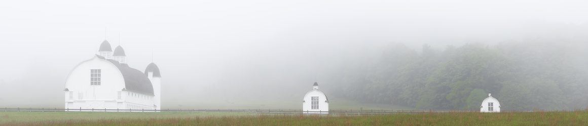
I can’t stop taking photos of the granary on the Peter and Jenny Burfiend Farm in the Port Oneida Rural Historic District. The stark geometry and bright white of the granary make it stand out against the landscape, even when the landscape is covered with snow.

This is a photograph I took years ago of the Burfiend’s house that they built after establishing the farm in 1882.

I took this photo of the garage on the farm yesterday.

Across the field and beyond a swamp on the shore of Lake Michigan is the farm of Peter Burfiend’s father, Carsten, and mother, Elizabeth. There are several outbuildings on the farm, but only the foundations of the barn and silo remain.

On the way home, I stopped in the southern portion of the park where the Platte River flows into Lake Michigan. There I found a spot where the snow had blended with the sand of a dune between the river and the lake.


Earlier this week, I drove north to Sleeping Bear Dunes National Lakeshore, my old reliable spot for finding interesting things to photograph. I am sure that I pass many wonderful scenes as I make the three hour drive early in the morning, but Sleeping Bear has my heart and calls out to me in all seasons of the year.
The day was cold and windy. The combination of 20 degree temperatures (Fahrenheit) and winds gusting to 45 miles per hour, created a windchill that hovered in the single digits. Nonetheless, I headed to the beach to see how the shore ice had developed. On my last trip to Sleeping Bear, just two weeks ago, there was no shore ice. But the cold temperatures and high winds in the intervening days made all the difference. As I approached the beach from the parking lot at Esch Road and looked north toward Empire Bluff, I could see that the ice had indeed built up along the shore.

Waves crashed against the wall of ice. I thought of trying to capture some images of the waves, but realized that in the wind and the cold, I didn’t have the patience to stand in wait for the right wave to come along. Besides, once I got down to the shoreline, my view of the lake was blocked by the ice wall, so I could not see the action of the waves and could not anticipate when to trigger the shutter.
I decided that making images along the shoreline would be the order of the morning. Ice balls formed a ridge just feet from the shore, bringing to mind the spine of some ice creature laying in wait.

Along the shore, the sand cracked underfoot.

Otter Creek flows into Lake Michigan at the Esch Road Beach. I visited Otter Creek back in December, expecting to photograph images of snow and sand but was disappointed by the lack of snow. On my trip earlier this week, there was plenty of snow but Otter Creek itself was free of ice except along its shores.


Photographing in such bitter cold calls for some compromises. I returned several times to my car to change camera lenses. There was so much sand blowing in the wind that it would have been unwise to do so on the beach. I ended up leaving my glasses in the car since they kept fogging up. I had to trust my camera’s automatic focus because, without my glasses, I could not check critical focus on my camera screen. A number of images for which I used a slow shutter speed turned out to be blurry. Even on my tripod, my camera shook in the wind.
After a couple hours on Esch Road Beach, I drove to Sunset Shores Beach on Sleeping Bear Bay. The road to the parking area had not been plowed, requiring a short hike through a foot of snow to reach the stairway to the beach. The ice wall at Sunset Shores was not as large as the one at Esch Road, so I could look across the Manitou Passage to North and South Manitou Islands and could see the action of the waves.


At the base of the stairway to the beach, this cedar tree caught my eye. I liked how the pattern of the bark contrasted with the smooth, white snow. I decided that the image worked best in black and white.

The images I made on this trip were serviceable. None are really notable, but they testify to the beauty of the beach in winter. Even without a “prize-winning” image, I would mark the day big success. I enjoyed meeting the challenge of working in the bitter cold. Not surprisingly, I was the only person on both beaches. To have such a remarkable place to myself was a gem. I can’t wait to return.
I visited the Carl Creek Crossing Preserve in Ada, Michigan, today. A friend told me of this lovely little 8-acre preserve with a gentle stream passing through it. I arrived as the sun was rising. Here are some photos from my visit.


Grand Rapids is under the influence of an artic blast. Today’s high temperature was in the single digits and the windchill was around negative 10 degrees. A perfect day to visit Seidman Park and Honey Creek. Here are some photos from a chilly afternoon of photography.


It is cold. Our window have frosted over, allowing me to make this image.

Earlier this week, I visited Sleeping Bear Dunes National Lakeshore. Initially, I set out to photograph on Esch Road Beach, but the cold temperature and high winds convinced me that I needed to find a spot sheltered from the wind. I made my way to Good Harbor Bay at the point where Shalda Creek empties into Lake Michigan.

Shalda Creek originates at the west end of Little Traverse Lake and winds its way through wetlands and the forest until it reaches Lake Michigan. I make a point of stopping there on almost every visit to check out the work of the beavers who are altering the landscape as they dam the creek and to enjoy the peaceful surroundings, which I usually have to myself. Notwithstanding the work of the beavers, the creek keeps flowing toward the lake making its mark on the land.


The force of the water continually adjusts the path of the creek as it approaches the lake. Each time I visit, the mouth of the creek has moved a little or a lot.

On Wednesday’s visit, I found the creek had formed a small depression in its path creating a mini-waterfall.
