Suzanne Fritz-Hanson, who co-hosts the Everyday Photography Every Day podcast with photographer Michael Rubin, coined the phrase “get the cliché out of the way” to suggest how photographers should deal with the urge to take the obvious photo that everybody snaps. Who can resist taking a photo of Tunnel View in Yosemite Valley or a sunset over Lake Michigan? And why shouldn’t you take your own photo of the iconic scene, even if it is a cliché? Once the cliché is in the bag, you can move on to shooting popular subjects from unusual points of view and creating original images.
I recently returned from spending a week with my family at my frequent haunt, Sleeping Bear Dunes National Lakeshore. The focus of the week was spending time with my son and his family, but I did get out in the early morning and on a couple of evenings to take some photographs. In the limited time I had, I fell back on the clichés, photographing things I have seen countless times before. My excuse is that I was working with a new camera, learning how to use all the new features. And besides, it was fun. So here’s a mishmash of photos from the trip.

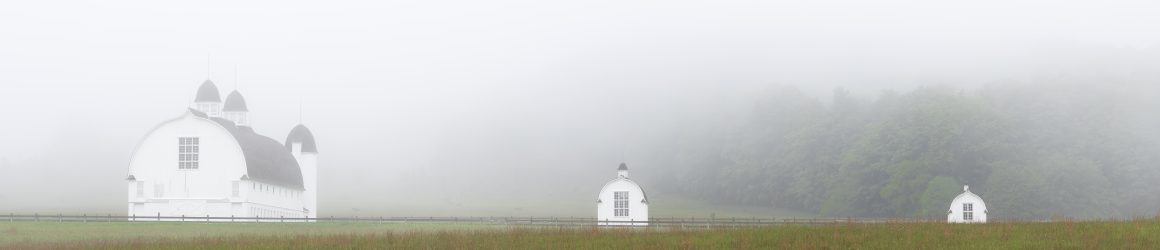
What could be more cliché at Sleeping Bear than a photo of the iconic barns on the D.H. Day farm? I was there on two foggy mornings and couldn’t resist.

This tree that stands in Narada Lake may not be an iconic image, but it is one I frequently photograph, hoping to find the right light and right angle to make a compelling image. I rarely succeed. But this sunrise with bands of clouds made the scene worth taking.

On another foggy morning, I headed to North Bar Lake. The fog had mostly lifted but the reflection of the trees and the dune in the water and the curvature of the cloudbank drew my attention.

The fog lingered on the south end of North Bar Lake. There, I noticed a pair of Sandhill Cranes walking along the beach and approached them cautiously to get this photograph.

If you search for “Teichner” on this website, you’ll see that I have photographed the cedar trees at the Teichner Preserve several times in the last six years. Perhaps the site is becoming cliché for me, but I am drawn to the location and keep looking for new perspectives on the scene. (If you are looking at this on a computer rather than a phone, click a photo to seen an enlarged image.)


Another site I return to often is the Basch farmstead in the Port Oneida Rural Historic District. The simplicity of the house and the granary continue to draw my eye. The light on this evening reminded me of the light in some of Edward Hopper’s paintings.


One evening when the conditions seemed right, I headed to the beach at Port Oneida to photograph that mother of all clichés, a sunset over Lake Michigan. When I pulled into the parking area, I was captivated by the dappled light on the trees.

On the shore, I waited and waited for the ball of the sun to appear. It never did. Others who were on the beach with me impatiently left, but I waited around to see how the setting sun would light up the clouds. Taking a long exposure, I captured a beautiful, soft glow as the sun slipped below the horizon – a photo I would consider more than a cliché .


