North Unity was a community founded in 1855 on Good Harbor Bay in Leelanau County, Michigan. The community was founded by families from Bohemia, which today is part of the Czech Republic and Germany. Francis and Antonia Kraitz were two of the first members of the community. They built this cabin in 1856.
The Kraitz cabin is just inside the border of the Sleeping Bear Dunes National Lakeshore. When the National Park Service took possession of the cabin, it was covered with clapboard siding and appeared to be a run-down 1940s-era cottage. But, upon removing the siding, the Park Service found a well-preserved log cabin. The cabin has just recently been restored by volunteers from Preserve Historic Sleeping Bear, a nonprofit partner of the National Park.
The Bohemian community of North Unity was were served by itinerant priests from the Catholic mission at Peshawbestown. Services were conducted in the homes of the congregation until this church building was completed in 1886. Today, the St. Joseph Parish has been merged with St. Rita’s Parish in Maple City. Mass is conducted in the St. Joseph Church only twice a year.
North Unity was established Shalda Creek where it flows into Good Harbor Bay.
This is one of my favorite places in the National Lakeshore to take photographs. The area is changing due to nature’s engineers. Beavers have built a small dam on Shalda Creek flooding the area behind it.
One final shot. This one was taken on Narada Lake. The old North Unity School sits on the shore of Narada Lake. I wasn’t able to get a good photo of it yesterday. (It is basically the same construction as the Kraitz cabin.) But, I thought this image was worth taking.
“Woodland Studies,” an exhibit of six of my photos, opened today at the Glen Arbor Arts Center in Glen Arbor, Michigan. The exhibit will run until April 13. The exhibit can be viewed online at https://glenarborart.org/events/exhibit-woodland-studies/. That page also has a link to a video of a conversation about the exhibit that I had with Gallery Manager Sarah Bearup-Neal. I have also embedded that conversation below.
[Note: “Woodland Studies” is no longer available on the Glen Arbor Arts Center website. You can see the photos in the exhibit on my website by clicking here.]
I am grateful to the Glen Arbor Arts Center for hosting this show and especially to Sarah Bearup-Neal for guiding me through the process of preparing my first exhibit.
The fall colors in northern Michigan are past their peak, but I was still treated to a beautiful color show yesterday at the Sleeping Bear Dunes National Lakeshore. This first photo, taken where Shalda Creek crosses Bohemian Road, reminds me of the final words from Thoreau’s Walden Pond: “Only that day dawns to which we are awake. There is more day to dawn. The sun is but a morning star.”
Shalda Creek snakes through Sleeping Bear just south of Good Harbor Bay and pours out into the bay. Shortly before it does so the beaver have built a dam creating a pond in the forest.
As I passed by, I noticed the reflection of the golden leaves in the still water of the pond and stopped to take these photos.
Driving home along Indian Hill Road in Benzie County, I pulled over to take this photo of a lone tree in a plowed field.
The fall colors have been late in coming to Michigan this year. I am guessing that we are still a couple of weeks away from peak colors in southwest lower Michigan. I drove north yesterday hoping to find nature’s brilliant display. I can report that the area on my route from Cedar Springs north to Thompsonville put on quite a show. But as I reached the Leelanau Peninsula, it remained pretty green. That’s good for the tourist industry on the peninsula, as leaf peepers will continue to be drawn to the area, extending the season. It was not a bust, by any means. There were pockets of color, harbingers of what is yet to come.
I began the day in the field below the iconic D.H. Day barns near Glen Haven. I waited in darkness for the sun to rise and light up the clouds from underneath. That never quite happened, but the image below was still worth the wait.
I found some dramatic red colors on Tucker Lake, beneath Miller Hill.
I hiked along the Crystal River for a bit and came upon salmon spawning on a gravel bed. It was amazing to watch as the dominant male chased off other males and the females prepared to lay their eggs.
This trout stood still long enough for me to capture a semi-decent photo.
Here’s a dash of color I found along Bohemian Road (CR 669) near Shalda Creek.
The weather was interesting, with intermittent rain showers and sunshine. I took the photos above in my rain gear, holding a large umbrella over my tripod and camera. Rather than hiking in the occasional rain shower, I stayed close to my car and visited a few of the historic farms in the National Lakeshore.
The Bufka farm is near the northern boundary of the National Lakeshore, along M-22. It sits down in a valley below the highway. The farm was established in the 1850’s by Joseph Bergman, an immigrant from Germany. Bergman built a log cabin that still stands today and can be seen in the photo below (the building farthest to the right). Charles Bufka purchased the 200 acre farm in 1880 and, over time, built the buildings (other than the chicken coop) seen in the photo. Upon purchasing the farm, he also built a house. The cabin was converted to a chicken coop in 1940. More information about the Bufka farm can be found here, on the National Park Service’s website.
I visited the Ole and Magdalena Olsen farm on Kelderhouse Road in the Port Oneida Rural Historic District. Ole Olsen was brought to North America from Norway by his grandparents in 1869 when he was 14. His grandparents settled in Sarnia, Ontario. Ole went to live with his uncle in Northport, on the Leelanau Peninsula. But soon his uncle and his family left to stake a claim in Minnesota under the Homestead Act, leaving Ole alone in Northern Michigan. In the early 1870s, Ole worked in the logging industry. In 1875, her met and married Magdalena Burfiend, whose father, Carsten, owned a 275 acre farm on what was the most valuable land in Port Oneida. With the help of Carsten Burfiend, Ole and Magdalena purchased their farm in 1877.
I took just a few photos on the Olsen farm, including this photo of the foundation for the barn.
The photo below is of the pig pen on the Olsen farm. Someone had placed a row of apples from a nearby tree on the window sill.
The photo below is of the farm buildings on Carsten Burfiend’s farm, with a lovely splash of color in the background.
As I left to return home, I drove by the Tweedle Farm on Norconk Road, south of the town of Empire.
Before driving home, I took one more photograph, a panoramic shot of the trees along Aral Road in Benzie County. While the colors had generally not reached their peak in the areas I visited, there were still areas of resplendent displays of fall foliage. Rain or shine – and I experienced both – it was well worth the trip.
Some photos taken yesterday morning as the sun rose on Esch Road Beach in the Sleeping Bear Dunes National Lakeshore.
Waves on Lake Michigan cut away at the beach, leaving this temporary pool.Clouds over Lake Michigan.Incoming waves swamp a stump that has washed ashore.For a brief few moments, the receding waves created this pattern in the water. A crocodile? Nessie?
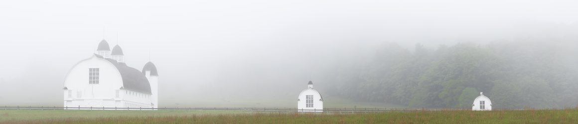
I drove north to the Sleeping Bear Dunes National Lakeshore earlier this week. It is a trip I take regularly. My drive takes about 3 hours. The anticipation builds as the first hints of morning light begin to reveal the conditions. The last three times I have made the trip, I drove through areas of fog, giving me hope that my destination would be shrouded with interesting atmosphere. On my previous two trips, the fog dissipated about 5 miles from the lakeshore. But, Tuesday a low fog hung on for me.
Noticing that the fog lingered in open fields, I decided to start photographing in the Point Oneida Rural Historic District. I started at the Pete and Jennie Burfiend farm. I have taken photos of this old granary at all times of the year. Enamored of its simplicity, I am drawn back time and time again.
Up the road from the Burfiend granary is the Martin and Allay Basch Farm. Fog engulfed the fields on both sides of the farm buildings.
Continuing on Baker Road (formerly known as the “Back Road”), I came to a clearing that overlooks the wetlands along Kelderhouse Road and took this panoramic shot.
Off to the side of the clearing was this tangle of poplars.
The clearing also overlooks the Carsten and Elizabeth Burfiend farm on Point Oneida Road. The Burfiends homesteaded the land, which sits on the bluff above Sleeping Bear Bay, in 1852.
I ended my morning shoot photographing the Tucker Lake wetlands along S. Westman Road. This area has frustrated me in the past, as it was just a little bit beyond the reach of my 70-200 mm lens. I recently upgraded to a 70-300 mm lens, which enabled these shots.
Landscape photographers generally aren’t excited by cloudless, bluebird skies. In composing the “grand landscape,” an empty sky is negative space that most of the time adds little to the composition. I have seen a lot of bluebird skies this spring and early summer. But on Tuesday, I was treated to some great clouds.
I hiked the Sleeping Bear Point Trail in Glen Haven, Michigan. The main trail travels 1.9 miles up and down over the sand dunes. After the initial climb, you drop down to an area known as the ghost forest.
The ghost forest has the remains of trees that were buried by the dunes and that have now been exposed as the dunes shifted.
After completing the trail I headed off to other parts of the Sleeping Bear National Lakeshore. While shooting at the Thoreson Farm, I noticed the clouds building off to the west and headed down to the shore of Sleeping Bear Bay in time to catch a thunderstorm coming ashore. In the distance, a great lakes freighter made its way through the Manitou Passage under a roll cloud.
The roll cloud extend across the sky.
The storm spawned several waterspouts like this one.
I continued taking photographs until I thought better of standing on the shore amidst the lightning.
Grateful for the dramatic skies, I headed back to my car and the safety of lunch at the Good Harbor Grill.
I traveled north to the Leelanau Peninsula early Saturday morning. It was a snowy drive and took me about an hour longer than normal. But once I arrived and the sun came up, I was treated to awesome beauty.
My first stop was Point Betsie, shortly before sunrise. I was curious to see whether in the intervening weeks since I last visited (February 2) the ice had built up on the trees and bushes south of the lighthouse. While ice had built up on the breakwaters, the ice that had formed on the trees was not what it was three years ago when I visited in January. Back then the trees were thick with ice and the place was thick with photographers.
I ventured next to the Platte River near the point where it enters Lake Michigan. To get the perspective, I wanted I waded into knee deep snow. The scene was peaceful, interrupted only by a beaver swimming by and two swans that flew overhead making a terrible racket.
The needles of larches, or tamarack trees, typically turn a golden orange and fall to the ground in the fall. They are beautiful trees in their fall colors. This young larch on the river’s edge managed to hang onto its needles as a winter coat.
All along M22 the road and the trees were covered in snow. I seemed to have the place all to myself.
The trees glistened as the sun rose in the east. I pulled to the side of the road on M22 to get this shot of trees in an open field on the edge of the forest.
The scene below is Otter Creek where it crosses Aral Road in the Sleeping Bear Dunes National Lakeshore. This is the site of the town of Aral, a booming mill town in the 1880s. Nothing remains of the town today except for a large concrete block that likely served as a base for the sawmill that was about 25 yards east of this spot. An old map shows that this area is where the mill pond formed when Otter Creek was dammed.
Today, Otter Creek flows freely into Lake Michigan except, of course, in winter when shore ice builds and obstructs the the creek’s pathway, as shown in this photo. In the background on the right is Empire Bluff.
Yesterday was a beautiful winter’s day, with plenty of sunshine, something we see little of this time of year. It has been a quiet winter, with with relatively warm temperatures and lots of clouds. On the Leelanau Peninsula, where I headed yesterday, they had received just 26.4 inches of snow as of Wednesday morning, compared to 87.8 inches a year ago. So far in January, the Leelanau has received just 4 inches.
I arrived at Good Harbor Bay an hour before sunrise. It’s a very short walk through the woods to where Shalda Creek flows into the Bay. The clouds were beginning to break up, allowing morning’s first light to illuminate the scene.
There was just a thin layer of ice on the beach.
I hiked back into the woods, following Shalda Creek upstream, but couldn’t find a composition. So, I got back in my car and drove to Esch Road Beach, south of Empire. I have pictures from years past in which the ice pack had mounded along the beach. That’s not the case this year, though the surf is transforming this tree into an ice sculpture.
My final shooting location before grabbing lunch and hiking on the Sleeping Bear Dunes Trail was Inspiration Point above Big Glen Lake.
While at Inspiration Point, I took a moment to photograph the Faust Cabin, which was build in 1929.
I tarried at Inspiration Point for a while, enjoying the view and watch a bald eagle soar over the open water, perhaps keeping an eye out for a meal.
On Saturday, we had a full moon for the second time in October. The moon set at 8:10 a.m., so I thought it would be good time to capture a photo of the moon close to the horizon. Things didn’t quite go as I had planned, but it was a wonderful morning for photography.
Prior to my trip to Sleeping Bear Dunes National Lakeshore, I used a couple of apps to find the right spot to shoot the setting moon. I needed something of interest in the foreground. What I hadn’t considered was that it would be dark and cold. I hadn’t given enough thought about how to balance a dark foreground against the brilliant light of a full moon. Still, I got this shot, which I like very much.
I chose to shoot the setting moon at a familiar spot, the Peter and Jenny Burfiend farm at Point Oneida in the Sleeping Bear Dunes National Lakeshore. Sunrise would follow the moonset by about 15 minutes, so as I stood in a field, the sky became brighter, allowing enough light that the granary was no longer silhouetted.
According to a map I have of Point Oneida, this is the old pig house on the Burfiend farm.
As the sun came up, I was surprised to see the beautiful fall colors still on the trees. This is the house on the Burfiend farm.
After stopping at Bass Lake, I drove to nearby Narada Lake. The corner of the lake near the Sleeping Bear Heritage Trail had a thin layer of ice that would disappear later in the day.
The view across Narada Lake was every bit as stunning as that on Bass Lake.
In the shadows of Narada Lake I saw this reflection of the leaves and a single dead tree that was bleached white.
Lily pads were frozen in ice.
This is the barn on the Lawr farm, which adjoins the Burfiend farm.
George and Louisa Lawr established the farm in the 1890s and and continued to farm there until 1945.
My last site for shooting was along Westman Road, in the wetlands north of Tucker Lake. These berries caught my eye.
The bright yellow tree is a tamarack, also known as an Eastern Larch. Tamaracks are conifers that grow in the wet soils around swamps and bogs and near lakes. Unlike other conifers, each fall their needles turn bright yellow and fall to the ground.
These maples leaves had fallen onto the ice in the wetlands near Tucker Lake.
The weather forecast called for snow on the Leelanau Peninsula last evening. I am sure the next time I venture north, the area will present starkly different things to photograph.