Over the weekend, I attended the opening of “The Sky Is Always There,” a new juried show at the Glen Arbor Arts Center. The Arts Center asked applicants to go beyond direct representation and portraits of puffy clouds “to consider the sky from its atmospheric characteristic to its mythic history.”
I was fortunate that my submission “Noctures” was accepted for the exhibit. Nocturnes is a triptych of photographs of the night sky that I printed as cyanotypes.
From left to right, the images are of a moonrise over Shalda Creek, the Milky Way over Port Oneida, and the northern lights over a farmhouse in Kirkjubæjarklaustur, a village in the south of Iceland.
I shared the inspiration for my entry in my Artist’s Statement: “When my children were young, we would lie on the shore of Sleeping Bear Bay at night and watch for satellites. Those moments when we marveled at the night sky have remained with me all these years. I wanted to recreate that sense of awe for this exhibit. More recently, my grandchildren and I created cyanotypes of leaves and twigs. We shared a similar sense of wonder as we watched the images coming to life in the developing tray. These experiences gave me the idea to process photographs of the night sky as cyanotypes for this exhibition.”
To create the cyanotypes, I converted my digital photographs to monochrome images and then reversed the tones to create digital negatives. Using a mixture of ammonium iron citrate and potassium ferricyanide, I treated hot-pressed, 100% cotton watercolor paper to sensitize it to UV light. Then I made a printed image from each negative by exposing the negative and paper to a UV light source. To deepen the blues, I bathed the final prints in hydrogen peroxide.
There are some remarkable works in the exhibit. If you are in the area of Glen Arbor this winter, I encourage you to stop by the Glen Arbor Arts Center and enjoy it. The exhibit runs through March 20.
As I write this, 2024 is quickly coming to a close. Time once again to look back and select some photos from this year that I especially like.
This year was a little different from previous years because my main photography focus for the year was researching and preparing two lectures that I delivered in November at the Osher Lifelong Learning Institute (“OLLI”) at Aquinas College. The lectures were titled, “Editing Reality: The History of Manipulated Photography.” The first lecture dealt with the period before the digital age, while the second began with the digital age and got into the consideration of the impact of artificial intelligence on photography. I had a blast doing the research, reading a wide range of sources and, though the lectures are done, my reading continues to focus on the history of photography.
Incidentally, I was honored that OLLI sought my permission to use my photographs on their Fall and Winter Course Catalogs.
I am principally a landscape photographer who shoots in what some have termed, “the eyewitness tradition.” I edit my photos to create a realistic image that truthfully presents how I saw what was before me when I clicked the shutter. I do not use generative artificial intelligence or insert items into my images that were not before me. That said, this year I experimented making multiple exposure and montage images. There were two that I particularly liked.
I created this first image from three exposures taken of the side of a dumpster at the East Grand Rapids Public Works Facility. I blended them together in Photoshop. I rather liked the result.
This tree is one of my favorites. Standing alone in a farmer’s field, it reveals its majesty. On the day I took this photo, the sky was cloudless. While the sun was shining and the sky was a beautiful blue, to my eye, the sky offered nothing of interest. Photoshop now allows one to replace the sky with a menu of clouds. Doing so seems disingenuous and certainly would violate the eyewitness tradition I adhere to. Rather than create an artificial photo and present it as real, I chose to try something a little different – a composite of two photographs, one the photo of the tree and the field, the other an image of the bark of a tree for the sky.
Earlier this year, the Glen Arbor Arts Center put out a call for entries to a juried show titled “The Sky is Always There.” The prospectus called for entries that “move beyond direct representation, beyond portraits of puffy clouds.” I was eager to try to get something accepted for the show, but my photography is very representational. I gave it much thought but was coming up empty. Then, after creating cyanotypes of leaves and twigs with my grandchildren I got the idea of submitting photographs of the night sky processed as cyanotypes for this exhibition.
I selected three digital images – a moonrise, the Milky Way, and the northern lights – to create a triptych. From the digital files, I created monochrome negatives of each image. I used a mixture of ammonium iron citrate and potassium ferricyanide to sensitize hot-pressed, 100% cotton watercolor paper to UV light. Then I made contact prints from each negative by exposing the negative and paper to a UV light source. To deepen the blues, I bathed the final prints in hydrogen peroxide.
I am pleased to say that the juror selected my entry for the exhibit, which will run from January 10 to March 20, 2025, at the Glen Arbor Arts Center in Glen Arbor, Michigan.
Here’s a selection of more straightforward images that are among my favorites for 2024:
“Sunrise on Sleeping Bear Bay,” Sleeping Bear Dunes National Lakeshore
“Hall Lake Morning,” Yankee Springs Recreation Area
“Lake Superior Lakeshore from Above,” Pictured Rocks National Lakeshore
“Lake Superior Stones,” George Hite Dunes, Eagle Harbor, Michigan
“Milky Way,” Port Oneida Rural Historic District, Sleeping Bear Dunes National Lakeshore
“Northern Lights over White Lake,” Wabaningo, Michigan
“Hanging On,” Teichner Preserve: The Leelanau Conservancy
“Fall Foliage,” Howard and Mary Dunn Edwards Nature Sanctuary, the Grand Traverse Regional Land Conservancy
“Turkey Tail and Maple Leaf,” Houdek Dunes Natural Area: The Leelanau Conservancy
In the coming year, I will continue to research the history of photography. Of particular interest to me are cabinet cards created in the second half of the 19th century. I will also continue to deepen my understanding of generative artificial intelligence and its impact of the art of photography. And, of course, I will continue to get out with my camera in an effort to capture nature’s beauty.
Happy New Year
Here are links to my my year-end review of images in 2019, 2020, 2021, 2022 and 2024.
As I write this on the tenth day of November, fall has entered its final stages. The trees are done showing off, no longer flashing their brightly colored leaves. Their branches are now mostly exposed, revealing the superstructure of the forest. I traveled to northern Michigan this past week to spend a couple of days exploring the woods, looking for smaller, more intimate scenes that seem to become more evident when the trees stop showing off.
Most of the ferns in the forest were brown and withered. But, at Misty Acres in the Borwell Preserve in Benzie County, I found this bulblet fern that had found sanctuary in the bark of a tree.
At the Houdek Dunes Natural Area in Leelanau County, my eye was attracted to the yellow plant and the green pine tree seemingly enjoying their time in the sun.
I came across these tiny fungi that had latched onto a birch tree. I believe they are called orange mycena.
The Teichner Preserve in Leelanau County is a small preserve on the shores of Lime Lake. There is a short trail that leads from the road to the lake and a spot I call the “Gathering Place.” There, the cedar trees are in a struggle to avoid succumbing to waves that erode the shoreline. Their roots intermingle as if they are holding onto each other for dear life.
I stopped at the Howard & Mary Dunn Edwards Nature Sanctuary in Grand Traverse County specifically to get photos of the larch trees. Larch trees are the only coniferous trees that lose their needles each year. Before doing so, they turn a vibrant yellow.
Along the pathway, I paused to take photos of the brightly colored leaves and needles that were still hanging on.
Here’s a couple of other things that caught my eye along the trail.
At Sunset Shore beach in the Sleeping Bear Dunes National Lakeshore, I took time to enjoy the setting sun as a stiff wind blew on shore. In the woods above the beach, I came upon this cedar that grew up around some boulders. All in all, a wonderful couple of days in nature.
Earlier this week, I spent an early morning at the Sleeping Bear Dunes National Lakeshore. On my monthly trips to Sleeping Bear, I usually leave home without a plan. When I reach Copemish, two hours into the three hour drive, I check the weather map and decide whether to take County Road 669 to Good Harbor Bay, County Road 677 (the old Benzonia Trail) to Glen Lake, or continue on M115 toward Frankfort to enter the park from the southern end. This week, I knew exactly where I wanted to go and traveled the country roads until I got to Bass Lake and Otter Lake, south of Empire.
Before the dawn on Otter Lake
Sunrise on Otter Lake
Bass Lake and Otter Lake are joined by a small stream. Water flows from Bass Lake into Otter Lake and from there into Otter Creek, which meanders its way to Lake Michigan at the Esch Road Beach. The area is home to a large number of eastern red cedar trees.
I wanted to visit the area to photograph the roots of cedars that had fallen over. Eastern red cedar trees generally have a network of lateral roots not far beneath the surface. As such, the the trees seem to be prone to tipping as the surface soil erodes. I am intrigued by the roots of fallen cedar trees, the way they twist together in the struggle to keep the tree erect. Torn from the ground and bleached in the summer sun, the roots become nature’s sculpture. Here are some of the images I took.
At the end of each year I look back at the images I have taken and select several to highlight in a year-end post. This year I have selected 15 photos to share and discuss. Whether these images are my “best” or not, I am not sure. But, they are all images that gave me a sense of achievement in expressing my vision.
Winter Scenes
I will start with four images I took in the winter. Winter is my favorite time to do photography. I love being outside in the winter. I find the cold and the snow to be invigorating. Snow can be a landscape photographer’s friend helping to reduce the chaos that so often typifies a scene in nature, especially in a woodland. I have photographed this sumac several times over the years, but found it difficult to get it to stand out from the trees behind it. I made this photograph in a snow storm, which helped to reduce the chaos in the scene, creating separation between the twists and turns of the sumac and the forest in the background.
I first came across this lone tree in a farmer’s field in the fall of 2021. I described it then as one of my “U-Turn” photos – a scene that caught my eye as I was driving by and caused me to do a u-turn. It happened again this past winter. I drove by this tree while it was snowing and again did a 180 and pulled off by the side of the road. A lone tree is a frequent subject for landscape photographers. It can evoke a range of emotions, such as isolation, tenacity, or independence. Having captured a photo in the fall and winter, I will have to return to this spot in the spring and summer to document it in all four seasons.
Walking along Shalda Creek where it enters Good Harbor Bay in the Sleeping Bear Dunes National Lakeshore, I saw these stones frozen in ice. As I photographed them, a haiku came to mind:
Stones encased in ice
Imprisoned by winter’s cold
The beach in February
A good photograph has something in common with a haiku. A haiku expresses its meaning in three spare lines – no wasted words or syllables. In a photograph, everything has to contribute – no extraneous things to distract from the subject.
On my frequent drives to the Leelanau Peninsula, I pass the Weldon Township Cemetery in a clearing cut from the forest. I have stopped several times to try and capture the emotion of the scene without success. But, the winter’s snow helped to emphasize the simplicity of this hallowed place and to convey a sense of repose and honor.
My Swan Vigil
In March, I went for a walk along Reeds Lake in East Grand Rapids, Michigan, and came across a swan sitting on a nest. I continued to visit the nest for two and a half months, hoping to be able to document the hatching of the swan’s nine eggs. The eggs never hatched, but I was able to put together a blog piece on my vigil. Here is the link. The male swan (the cob) was very protective of the nest. In this first photograph, the swan is taking off to confront another pair of swans a couple hundred yards away – apparently too close for the cob.
In the area of the swans’ nest there were many nesting geese. The cob policed the area to let the geese know their place in the order of things. Photographing birds was a challenge for me. I take photos of landscapes with my camera on a tripod, often with a long exposure time. I have the luxury of time to frame a shot and try different apertures and focal lengths. But birds don’t wait for you. You have to react and hope that you snap the photo at the decisive moment. I learned to observe and anticipate.
Iceland
In September, my wife and I visited Iceland. We concentrated our journey in Reykjavík, on the Snæfellsnes Peninsula, and along the southern coast. Iceland is an amazingly beautiful country. Berserkjahraun, seen below, is a vast lava field on the Snæfellsnes Peninsula that formed 4,000 years ago. The lava field is covered with moss and lichen and offers a stunning view with mountains in the background.
I had never photographed the northern lights before. I got the opportunity when we rented a cottage on the southern coast, near Kirkjubæjarklaustur. We watched for nearly four hours as the aurora filled the night sky. The naked eye saw only the greenish colors, which danced in the sky. But, a longer exposure – nine seconds or so – captured the magenta.
On the southeast coast of Iceland is Jökulsárlón, a glacial lagoon dotted with icebergs that break off a glacier and make their way to the sea. My eye was attracted to the layers of tones in this scene.
Iceland has over 10,000 waterfalls. Probably the four most visited falls are Öxarárfoss at Þingvellir, Gullfoss on the Golden Circle, and Seljalandsfoss and Skógafoss along the south coast of the country. All have large parking areas to accommodate the tourists who flock to the sites. We ventured off the main highway to a less visited waterfall, Gluggafoss, also known as Merkjárfoss, where we had the site almost to ourselves (other than the one woman in a bright red coat who kept walking into my photo while talking on her cellphone). Gluggafoss falls in two stages and has a total height of 171 feet. The lower falls are captured in the photo below.
Black and White
I continue to try to develop my eye for processing photos in black and white. Gluggafoss rendered well as a black and white photo, with a broad range of tones.
Back home in Michigan, I look for scenes that I think will be effective in black and white. Processing in black and white reduces a scene to its essence. It relies on structure and form, light and shadow to carry the photograph’s meaning. The great Magnum photographer Elliott Erwitt, who died in November, said of black and white photography, “Color is descriptive. Black and white is interpretive.”
I am attracted to the roots of trees, so I was excited when I came upon these cedar trees along the shore of Lake Michigan. Waves had eroded the shore exposing the lateral roots and tap root that have supported the trees for tens of years. Another period of high water and waves will likely mean the end for these trees.
I was recently studying the work of Wynn Bullock and came across his solarizations. Solarization is a technique in analog photography perfected by Man Ray. When developing film in the dark room, Man Ray would briefly flick on the lights which would invert some of the tones in the finished photograph. In my digital darkroom, I attempted to emulate this process by adjusting the tone curve in Lightroom, lifting the deep blacks while maintaining the midtones and highlights. I found it difficult to emulate solarization effectively, but I did like the effect my method had on this image of the cedar roots.
A Gift
Sometimes an image is simply a gift. I parked in a parking lot in Glen Haven, Michigan, hoping to take some long exposure photographs of waves coming ashore in Sleeping Bear Bay. As my luck would have it, the bay was virtually still that day. When I walked back to my car, the sun had just crested a row of trees to the east lighting up these empty milkweed pods. Simple and beautiful. The experience brought to mind another quote by Elliott Erwitt: “To me, photography is an art of observation. It’s about finding something interesting in an ordinary place. . . I’ve found it has little to do with things you see and everything to do with the way you see them.”
Thank You
If you have gotten to this point, thank you. Over the course of the past year, I have become less and less interested in posting photos to social media sites like Instagram, where people breeze by the photos, swiping left or right, giving little time to each image. So I appreciate your giving me the gift of your time to look at and consider the photos in this post.
Here are links to my my year-end review of images in 2019, 2020, 2021, and 2022.
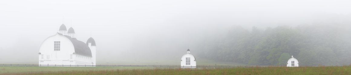
Earlier this week, I drove north to the Sleeping Bear Dunes National Lakeshore for sunrise. During the night, the temperature had dropped to near freezing. Cold air over the warm water of Otter Lake and Bass Lake created a beautiful fog that made the journey worthwhile. (Click on the image to see them larger.)
I had another chance to go north this weekend to try my hand at a little night sky photography. The last “Super Moon” of the year arrived on Thursday. As a bonus, mid-August is the peak of the Persied meteor shower. So, I planned a shot of the full moon the following night right between the silos of the D.H. Day Barn at the Sleeping Bear Dunes National Lakeshore. I used the Photopills app to determine where I needed to stand and the time I needed to be there to shoot the moon in all its glory above the barn. I was able to reserve one of the last available campsites at the D.H. Day campground and headed north.
In the afternoon, I used the augmented reality feature of Photopills at the D.H. Day farm to confirm that the shot would work. The photo below hints at the problem I would encounter. The wispy clouds in the sky are cirrus uncinus clouds. In Latin that means “curly hooks.” The clouds are commonly called “mare’s tails,” and are precursors of rain.
The sky was filled with mare’s tails. Things weren’t looking good, but I had several more hours before sundown and moonrise.
I decided to watch the sunset from Van’s Beach in Leland, Michigan. While waiting for the show, I snapped some photos of the boats in the harbor. The reflection of a sailboat’s mast caught my eye. I watched the reflection as it morphed with each passing boat.
It became clear that there would be no great sunset show and likely no shot of the moon over the D.H. Day barn. The clouds in the west were headed my way, fulfilling the prediction of the mare’s tails. I took a photo of the entrance to the harbor and then set upon my way, hoping the skies would be clear 20 miles to the southwest.
No such luck. At the D.H. Day farm, the sky was thick with clouds. I determined to go with my plan B, a shot of the Point Betsie lighthouse. Point Betsie was another 24 miles to the south. On the way, I stopped by the beach at Empire. There’s a small lighthouse there in the middle of a parking lot. When I got there, the parking lot was full of revelers enjoying the evening. The night was dark but there was a faint reflection on the water. An 11 second exposure looking into the darkness revealed what was barely visible to the naked eye.
Finally, I made it to Point Betsie. My goal was to get a shot of the light house with the lamp lighted. The challenge is that the lamp is so bright compared to the lighthouse itself that if you expose for the lighthouse, the lamp gets blown out and has no detail. But, I had a plan.
Every lighthouse has its own “signature.” Some lights rotate, some are stable. Some flash, while others stay lit constantly. The Coast Guard publishes a list of the signatures of every lighthouse and buoy in the country. I knew from the list that the Point Betsie light flashed white for one second every ten seconds. After much experimentation, I discovered that a 3.5 second exposure allowed for a proper balance between the lighthouse itself and the lamp. But the key was not having the shutter open for the full one second the lamp was on. I learned to open the shutter shortly after the lamp lit so that it was on for probably just a half second or less during my exposure. I was helped in getting a proper balance by the moon, which peaked through the clouds, lighting the side of the building. I augmented the moon’s light with a small light panel.
The photo reminds me of an Edward Hopper painting. Hopper, of course, lived and painted for many years on Cape Cod, an area that resembles the Leelanau Peninsula in many ways. His work has influenced many photographers.
Mission accomplished, I drove back to the campground and crawled into my sleeping bag about 1:30 a.m. I was awakened briefly at 3:00 a.m. by the sound of raindrops hitting my tent fly. Never doubt those mare’s tails!
Earlier in the week, Friday night looked like it would provide a great opportunity to try my hand at nightscape photography. The long-range weather forecast predicted clear skies, and the moon would not rise until long after the galactic center of the Milky Way would reach its highest point in the night sky. As luck would have it, the D.H. Day Campground at Sleeping Bear Dunes National Lakeshore had one campsite left for Friday night. So I reserved it and started planning.
I used an app called Photopills to identify possible locations to shoot. The app allowed me to locate a spot on the map and see where the Milky Way would be in relation to it in the night sky. I checked out several locations, finally deciding on three sites that would be close enough that I could cover each of them in one evening.
On Friday morning, I made the three hour drive to Glen Arbor, Michigan, and visited my intended locations during the afternoon. I used the augmented reality feature of Photopills at each site to confirm the position of the Milky Way at the times I intended to shoot. Now all I needed was clear skies.
I had been using three different sources to predict the weather for Friday evening. Two forecast clear skies and one predicted thunderstorms. Turns out, all three were partially right and partially wrong. As evening approached, so did some foreboding clouds.
Undaunted and certain that “this too shall pass,” I set up at my first location (the old cannery in Glen Haven) around 11 p.m. I could see some breaks in the fast moving clouds, but soon the rain began to fall. I jumped into my car and headed to my next location, hoping that the sky there would be clear. Within a few miles I was in the midst of a thunderstorm, so I pulled over to the side of the road to wait it out. It didn’t take long for the storm to pass. Within 10 minutes I was on my way again.
My second location was the bridge over the Crystal River on Country Road 675. People who have kayaked the Crystal know this bridge as the location where you “shoot the tubes,” the culverts that allow the river to pass under the road. Getting out of the car, I was pleased to see that the sky had cleared. I quickly donned my reflective vest and set some reflective triangles along the road to warn approaching cars that I was standing on the bridge with my camera and tripod.
The biggest challenge of photographing stars is getting them in focus. There are a couple of methods of doing so. The first one failed me completely. That method involves placing the brightest star in the middle of the camera’s LCD screen and magnifying it to allow you to focus. Sounds great, but on my LCD screen all I saw was darkness. On to method two – relying on the “hyperfocal distance.” The hyperfocal distance is a spot at which everything halfway from the camera to infinity will be acceptably in focus. I knew that for the focal length and aperture I was using the hyperfocal distance was 16 feet 6 inches. But how do you focus in the dark? I set my camera 16 feet 6 inches feet from the back of my car, shined my flashlight on my bumper and focused on it. And then I was in business.
There it was, just as Photopills had predicted, the Milky Way!
Having found success on the Crystal River, I moved on to my third location, the Carsten and Elizabeth Burfiend farm in the Port Oneida Rural Historic District. Carsten Burstein bought 275 acres in what became known as Port Oneida in 1852, when the government opened the land up to settlement. I was interested in photographing the farm’s granary, corn crib and shop.
I lit the buildings with two small LED light panels. Both were set at their lowest output and placed on light stands far away from the scene. To the naked eye, they provided little illumination, but to the camera, with its 8 second exposure, the lights provided about as much light as would a one-quarter moon.
Having met with success at my second and third locations, I headed back to the cannery in Glen Haven, unsure of whether the Milky Way would be positioned well to get the picture I wanted. After all, it had been nearly three hours since I originally had planned to shot there. While it is not the shot I had planned, it still worked out pretty well.
I was pleased with the evening’s success. Several years ago, I had tried my hand at photographing the Milky Way, but my equipment wasn’t up to the task. I recently purchased a “fast” lens that has a much wider aperture. That made a significant difference. The night provided everything I hoped for. . . and more.
Shortly before calling it a night, at 2 a.m., I checked in with a woman I had met earlier in the evening in the parking lot at Glen Haven. She had come north from Saint Joseph, Michigan, when she learned there was a chance to see northern lights. “Any success,” I asked. She said that indeed she had seen them. “In fact,” she said, “they are out there right now.” I looked off to the northwest and all I saw was a faint glow along the horizon. “That’s them,” she said, and she showed me some photos she had taken earlier in the night with her cell phone. So I set up my tripod and aimed it at the horizon, taking a twenty second photo. Sure enough, there was the faint glow of the northern lights.
The color wasn’t visible to my naked eye, but there on the back of my camera was the telltale green glow I have seen before. I switched from a wide angle lens to by telephoto.
I crawled into my tent about 2:15 and was up and out again at 5:30 a.m. to catch a different glow as the sun rose on Sleeping Bear Bay.